How to Maximize Aerial Surveillance with Drone-Mounted Thermal Imaging Cameras

Introduction to Drone-Mounted Thermal Imaging
In recent years, the utilization of drones in surveillance has experienced a remarkable surge, revolutionizing traditional methods of monitoring and reconnaissance. The advent of drone technology has significantly enhanced the efficiency and scope of surveillance operations, offering unparalleled advantages in various fields.
The Rise of Drone Technology in Surveillance
The integration of drones into surveillance practices has redefined the capabilities of aerial monitoring. With their ability to access remote or inaccessible areas, drones have become indispensable tools for law enforcement, emergency responders, and environmental conservationists. Their agile maneuverability and capacity to cover vast expanses make them invaluable assets in surveillance missions.
The Unique Advantage of Thermal Imaging
One of the most groundbreaking advancements in aerial surveillance is the incorporation of thermal imaging technology onto drones. This innovation has unlocked a new dimension in surveillance capabilities by enabling the detection and visualization of heat signatures from an aerial vantage point. Unlike traditional visual cameras, thermal imaging cameras can capture heat emissions from objects, making them exceptionally effective for various applications such as search and rescue missions, infrastructure monitoring, and wildlife conservation efforts.
As we delve deeper into this blog post, we will explore the underlying technology behind drone-mounted thermal imaging cameras and their pivotal role in maximizing aerial surveillance capabilities.
Understanding the Technology Behind Drone-Mounted Thermal Imaging Cameras
As we delve into the intricate workings of drone-mounted thermal imaging cameras, it becomes evident that these advanced systems operate on sophisticated technology that enables them to capture and interpret thermal data from their aerial vantage point.
How Drone-Mounted Thermal Imaging Cameras Work
The Science of Heat Signature Detection
Drone-mounted thermal imaging cameras function by detecting and capturing heat signatures emitted by objects and surfaces. This process is based on the principle that all objects with a temperature above absolute zero emit infrared radiation. The thermal imaging camera's sensor can detect this radiation and convert it into a visual representation, allowing for the visualization of temperature variations across the observed area.
Integrating Cameras with Drones
The integration of thermal imaging cameras with drones involves the seamless incorporation of these specialized cameras onto the drone's framework. This integration requires careful calibration to ensure optimal alignment and functionality. Once mounted, the camera interfaces with the drone's control system, enabling real-time transmission of thermal data to the operator's display unit.
Key Components of a Drone-Mounted Thermal Imaging System
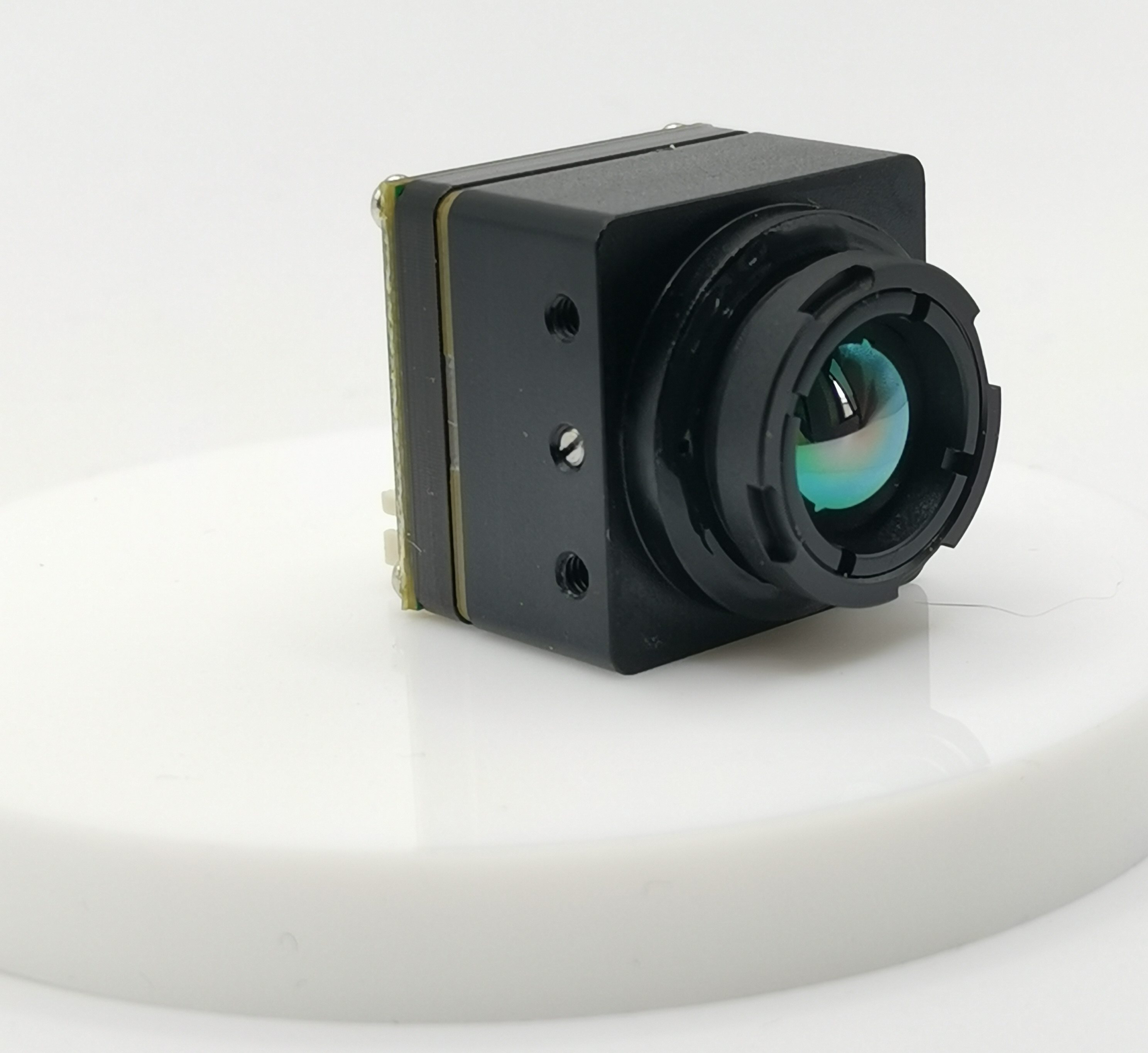
FPV Thermal Camera
A crucial component of a drone-mounted thermal imaging system is the First Person View (FPV) thermal camera. This high-resolution camera is equipped with advanced infrared sensors capable of capturing detailed thermal images from an aerial perspective. The FPV thermal camera provides operators with real-time access to thermal data, allowing for immediate analysis and decision-making during surveillance missions.
iSun Analog FPV Thermal Camera
Another notable inclusion in drone-mounted thermal imaging systems is the iSun analog FPV thermal camera. Renowned for its reliability and precision, this cutting-edge camera offers enhanced sensitivity to temperature differentials, ensuring accurate detection and visualization of heat signatures across diverse environments.
Utilizing state-of-the-art technology, drone-mounted thermal imaging cameras have revolutionized aerial surveillance capabilities, providing invaluable insights through their ability to capture and interpret heat signatures from an elevated position.
Practical Applications of Drone-Mounted Thermal Imaging in Aerial Surveillance
The implementation of drone-mounted thermal imaging technology has significantly expanded the capabilities of aerial surveillance, offering diverse applications across various fields. Let's explore how this advanced technology is revolutionizing surveillance practices in search and rescue missions, as well as infrastructure and wildlife monitoring.
Search and Rescue Missions
Night Operations
Drone-mounted thermal imaging cameras play a pivotal role in enhancing search and rescue operations, particularly during night missions. The ability to detect heat signatures allows these cameras to identify individuals or objects even in low-light conditions, providing crucial assistance to rescue teams operating in challenging environments or under the cover of darkness.
Locating Missing Persons in Challenging Terrains
In rugged or densely vegetated terrains where traditional search methods may be limited, drone-mounted thermal imaging cameras offer a distinct advantage. By capturing heat emissions from individuals or animals, these cameras aid in locating missing persons or stranded hikers within expansive wilderness areas, expediting search efforts and increasing the likelihood of successful rescues.
Infrastructure and Wildlife Monitoring
Detecting Heat Leaks in Buildings
Drone-mounted thermal imaging serves as an invaluable tool for infrastructure monitoring by enabling the detection of heat leaks within buildings. This capability allows for the identification of energy inefficiencies and structural anomalies that may not be visible through conventional visual inspections. By pinpointing areas of heat loss, thermal imaging contributes to energy conservation efforts and facilitates proactive maintenance measures.
Wildlife Observation and Poaching Prevention
In wildlife conservation efforts, drone-mounted thermal imaging plays a crucial role in observing animal behavior and detecting potential threats such as poaching activities. The ability to monitor wildlife from an aerial perspective while capturing their heat signatures enables conservationists to track animal movements, identify vulnerable species, and deter illegal hunting activities through enhanced surveillance measures.
By harnessing the power of drone-mounted thermal imaging technology, surveillance operations are empowered with unprecedented capabilities for safeguarding lives, protecting critical infrastructure, and preserving natural ecosystems.
Now let's move on to exploring strategies for maximizing the efficiency of drone-mounted thermal imaging systems in aerial surveillance.
Tips for Maximizing the Efficiency of Your Drone's Thermal Imaging Capabilities
As you embark on harnessing the full potential of drone-mounted thermal imaging technology, it is essential to consider key strategies for optimizing the efficiency and effectiveness of your aerial surveillance operations. From selecting the right drone and camera setup to enhancing your surveillance strategies, these tips will empower you to elevate your capabilities in capturing and interpreting thermal data.
Choosing the Right Drone and Camera Setup
Compatibility Considerations
When selecting a drone for thermal imaging applications, it is crucial to ensure compatibility between the drone platform and the thermal imaging camera. The drone should have the necessary payload capacity and mounting options to accommodate the specific thermal imaging system. Additionally, compatibility with software integration for real-time data analysis and storage is paramount for seamless operation.
Evaluating Camera Specifications
In evaluating camera specifications, consider factors such as thermal sensitivity, spatial resolution, and spectral range. A high thermal sensitivity allows for the detection of subtle temperature variations, while spatial resolution determines the level of detail in thermal images. Furthermore, assessing the spectral range ensures that the camera can capture a broad spectrum of heat signatures across different environments, enhancing its versatility in varied surveillance scenarios.
Enhancing Your Surveillance Strategies
Planning Optimal Flight Paths
Strategic flight path planning is instrumental in maximizing the coverage area and efficiency of aerial surveillance missions. By identifying target areas and defining optimal flight paths, you can systematically survey expansive regions while capturing comprehensive thermal data. Utilize mapping software to plan routes that prioritize critical areas of interest, ensuring thorough coverage without redundant or overlapping scans.
Interpreting Thermal Images Effectively
Effective interpretation of thermal images requires familiarity with temperature differentials and their implications in diverse contexts. Familiarize yourself with common heat signature patterns associated with human subjects, wildlife, and structural elements. Additionally, understanding environmental factors such as solar radiation and wind conditions can aid in accurate interpretation of thermal data captured during varying times of day or under changing weather conditions.
Utilizing these tips will enable you to leverage drone-mounted thermal imaging technology to its fullest potential, enhancing your capabilities in aerial surveillance while contributing to more efficient search and monitoring operations.
Incorporating these strategies into your practices will not only optimize your use of drone-mounted thermal imaging but also contribute to more effective surveillance outcomes across diverse applications.
Conclusion
The Future of Aerial Surveillance
As we look ahead to the future of aerial surveillance, the integration of drone-mounted thermal imaging technology is poised to play an increasingly pivotal role in enhancing monitoring and reconnaissance capabilities. The rapid advancements in drone technology and thermal imaging systems are driving a paradigm shift in surveillance practices, offering unprecedented opportunities for comprehensive aerial monitoring across diverse sectors.
The evolution of drone-mounted thermal imaging is expected to lead to further refinements in heat signature detection, spatial resolution, and real-time data analysis. These advancements will enable surveillance operations to achieve greater precision and efficiency in identifying and interpreting thermal anomalies, thereby expanding the scope of applications in law enforcement, emergency response, environmental conservation, and infrastructure management.
Furthermore, ongoing research and development efforts are focused on enhancing the portability, endurance, and autonomous functionality of drones equipped with thermal imaging cameras. This trajectory points towards the potential for extended flight durations, broader coverage areas, and seamless integration with artificial intelligence algorithms for automated anomaly detection.
Embracing Technology for a Safer World
The adoption of drone-mounted thermal imaging technology represents a proactive step towards creating a safer world through advanced surveillance capabilities. By leveraging cutting-edge technological innovations, stakeholders across various domains can fortify their ability to safeguard lives, protect critical assets, and preserve natural ecosystems.
Moreover, as the accessibility and affordability of drone-mounted thermal imaging systems continue to improve, these technologies have the potential to democratize aerial surveillance by empowering local authorities, conservation organizations, and emergency responders with cost-effective tools for efficient monitoring and rapid response.
In embracing this transformative technology, we embark on a collective journey towards fostering safer communities, mitigating risks proactively, and conserving our natural environment through informed decision-making based on comprehensive aerial insights.
As we stand at the precipice of a new era in aerial surveillance empowered by drone-mounted thermal imaging technology, it is imperative that we embrace these advancements as catalysts for building a safer world for current and future generations.
See Also
Optimizing Drone Surveillance: Leveraging Analog FPV Thermal Cameras
Enhancing Drone Potential: Deploying Analog FPV Thermal Cameras for Surveillance and Reconnaissance
Boosting Surveillance Effectiveness: FPV Thermal Camera in Commercial Drones
Maximizing Drone Potential: Utilizing Analog FPV Thermal Cameras
Becoming Proficient in Aerial Surveillance with Thermal Imaging Camera Drone: A Step-by-Step Manual
iSun digitech limited
iSun was established in 2007, specialising in automotive electronics, providing integrated software and hardware solutions. Products include Thermal imaging, Night Vision,Car Multimedia player, LCD Smart Car Key, CarPlay AI Box.

Contact Us: Ms. Coco Huang
E-mail: sales@iasun.cn
WhatsApp/Wechat: +86 13510421923